Virtual visits


Locally, last night’s Midsomer Murders was the episode, “Echoes of the Dead.”  Our PBS station’s purchased programs recently exhausted the Tom Barnaby episodes and we’re (finally) onto cousin John’s adventures. Not surprisingly, Cousin John’s cases have a slightly different feel to them than Tom’s. Having read about the change for ages, it’s nice to be (sort of) caught up. I’m guessing that I could catch myself up on a streaming service, but I like supporting a local station.

Because I like traveling, I’ve added to my enjoyment of the series by taking a virtual vacation to the filming locations in the story. During my travels, I can imagine either the film crew on location, or I can relive the story while ‘driving’ through the area by clicking arrow buttons on my laptop screen.

On the Sunday after a Saturday evening of murder and mayhem, it’s fun to drive around the area using Google Maps. No passport. No jetlag. No traffic jams. No murderers. The best part is that after my journey I get to sleep in my own bed. After decades of musical beds, whether in motels, hotels, or temporary Army quarters, ‘my own bed’ is a definite perk.

One thing to keep in mind concerning gazing around the filming locations is that the Google Maps images aren’t tidied up. I doubt anyone knew Google’s car would be driving by and so we don’t have all the pretty flower boxes, a street free of clutter, or the setting perfectly maintained. Still, the price is right.

Naturally, today’s virtual Sunday drive is to England.

The Red Lion Pub in Little Missenden, Buckinghamshire was renamed “The Monks Retreat” for the story. “Bernards hardware store” (IRL, the Village shop) is just to the right of the Red Lion/Monks Retreat.

Unfortunately for our outing, the train station for Great Worthy (in actuality, the Watercress Line in Ropley, Hampshire) was the site of the large building project when the Google Car made its pass through the area. Leaving the station, though, if you click-drive down the country lane out to a T-intersection, you can head either toward Winchester or Guildford.

Great Worthy school was filmed at Albury in Surrey. The Google car couldn’t get close, so neither can we.

The film crews cobble together lovely imaginary towns by trekking all over the countryside. I imagine they have a special team whose job it is to travel around to scout locations. (kind of a ‘duh’ statement concerning the sophistication of the film industry)

For me, virtually traveling to the filming sites adds depth to the stories. With no dialogue or jump-cuts in the Google Maps images, I can take my time, concentrate, and browse. I do miss the smells and sounds of the areas, and I can’t go out to a tea room for a little light refreshment. Still, as I mentioned above, the price is right.

Two years ago, I made a virtual visit to Shetland using Google Maps after watching a television version of Ann Cleves’s book, Dead Water.

This time, my virtual visit is to the Isle of Lewis. Lewis is far closer to the Scottish mainland than Shetland, but my overall impression was the same: wind, salt water, and weather.

Butt of Lewis lighthouse, Isle of Lewis, Outer Hebrides, Scotland


The reason for my virtual visit to the Western Isles is the book The Blackhouse by Peter May. I listened to it on Audible, and am now onto the next book, The Lewis Man.

In the book, Peter May writes so vividly that you all but cringe because of the drops of brine from The Minch shot into your face by the wind. My only connection to this part of the world is remembering my dad reminiscing about when we lived in England and he, like Mrs. Bale on the television show As Time Goes By, listened to the shipping forecast. My dad’s recollection of the information about the Scottish Isles was “gale force winds.”

The Blackhouse is a character-driven story. Everything hinges on Detective Inspector Fin Macleod’s background as he comes back to the Isle of Lewis to look into a murder with similar details to one he’s investigating in Edinburgh. In the reviews on Goodreads, this focus on character seems to be a love it or hate it factor. Some reviewers strenuously object to the focus on the importance of character rather than puzzle, but the book still has a solid 4-star (out of five) rating. As I’ve bought the next Audible book in the series, I can say that I enjoyed Peter May’s method of telling the story.

May’s story echoes historic events on the island. In my Google Maps drive around the island, I came to a beach I’d seen mentioned on road signs. Near the beach stands a memorial to a group of fishermen who were lost at sea.

A significant theme in the book is the culture of the island and the lore of the guga hunters, “guga” being the local name for the chicks of a seabird otherwise known as the gannet. May’s description matches the scenes in this video, but he doesn’t dwell on the “acquired taste” for the guga.

For my virtual travel, the combination of reading May’s story, my expedition via Google Maps, plus the guga video and article, provide an excellent (and passportless) outing to the Scottish Isles, with no jet lag.

Tickets, please!

As Memorial Day approaches each year, on social media many of us see reminders about the servicemembers buried in Arlington National Cemetery. It is well we remember those who gave their lives, soldiers, sailors, airmen, Marines, and Coast Guard members, at the cemetery and memorial meant for national observances. These men and women in Arlington, though, are not the only citizens, and foreign nationals, whom we should not forget. Around the country, forty states have national cemeteries, as well as Puerto Rico.

Besides the cemeteries and memorials for servicemembers in the United States, other nations honor our fallen along with their own. Around the world, the American Battle Monuments Commission, established in the Coolidge administration with John J. Pershing as the first Chairman, “administers, operates and maintains 26 permanent American military cemeteries and 30 federal memorial, monuments and markers, which are located in 17 foreign countries, the U.S. Commonwealth of the Northern Mariana Islands, and the British Dependency of Gibraltar …”

1998: Our visit to a WW1 military cemetery in the Somme region of France. The sheep are the lawn-mowers.

In the early 1970s while living in Germany near France, my husband and I and our toddler son visited Verdun, a devastatingly war-torn area during World War 1. We saw many reminders of the tragedy of war. Years later during a trip from Germany to England to visit friends who’d moved from Munich, Germany, my family visited the Cambridge American Cemetery. The chapel was sobering. A decade or so afterward, from our home in Belgium, we visited World War 1 cemeteries in the Somme region of France. Regardless of where American servicemembers are stationed, it seems there is no lack of memorials and military cemeteries. We have left our compatriots around the world.

On this Memorial Day, please spare a thought for the fallen American servicemembers who have given their all, but never made it home.


Our first snowstorm of the year was in November. Our weather forecasters have <cough> promised snow for next Monday. With luck, the snow already here will have diminished. The snow was pretty at Christmas, but it is wearing out its welcome. We see no snowmen. Children are not outside making forts. I see no one sledding.

I needed a vacation. So, I virtually went to Nairobi courtesy, as always, of Google Maps and Street View. Why Nairobi? Not sure, but no snow may have been a draw.

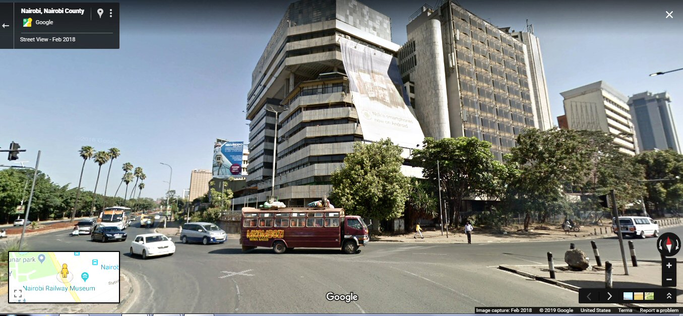
Haile Selassie Roundabout, Nairobi, Kenya

What did I do on my vacation? First off, I merely ‘parachuted’ into the city from my satellite view and landed where I landed. It wasn’t the best part of town. What I learned from not-the-best-part-of-town is that tire sales are big in Nairobi, well, “tyres.” That British influence. As I virtually drove down the street where I landed, I saw billboards for tires and auto parts. Along a rundown street, most of the shops in the three- and four-story buildings advertised the “tyres.” Auto parts, too. And driving lessons. I presumed Nairobi didn’t have much mass transit.

I was wrong. Popping up out of one part of town and into another (in big cities, driving takes forever whether you’re in a real vehicle or a virtual vehicle) I landed in an area in which buses stopped the Googlemobile from proceeding. Or maybe that’s my interpretation. In any case, as we approached a clot of buses, large and small, my forward-arrow no longer worked. I went back up, not quite into the stratosphere.

Coming back down, I looked for the city center. Found it — nice place. Not a single “tyre” sign near the Nairobi Hilton. I tooled around for a while, but nice parts of town seem to look much the same around the world: high rises, shops, boulevards, high-end cars. I went out of town.

Oh. My. Gosh. The Ngong Hills! How did I not remember that the Ngong Hills are so close to the city? (for those not in the know, read Out of Africa, by Isak Dinesen/Karen Blixen, or watch the movie of the same name with Meryl Streep and Robert Redford). “I had a farm in Africa, at the foot of the Ngong Hills.” The cinematography for the movie is breathtaking, especially in a movie theater. Oh, to have had IMAX at the time. That would have been marvelous. I’ll probably have to make do with watching the VHS tape. I’ll get out the Ouija board and conjure up Thomas Edison to watch it with me.

Time has marched on since the envisioning of Blixen’s story on film, and now the Ngong Hills have wind turbines and a massive solar energy farm. Kikuyu is now a Nairobi suburb with its own massive plant nursery Magana Flowers. Other relatively local sights are the Nairobi National Park , the Maasai Lodge, and the Karen Blixen Museum.  SafariNow, the company hosting the three previously-linked sites, has almost as many billboards and signs in Nairobi as do the tyre-sellers.

Among the other things I learned while virtually visiting Nairobi, are:

  • English is spoken if all the billboards and shop signs I saw are anything to go by
  • traffic runs on the left hand side of the road
  • many, many people walk all around the city — no Fitbits needed here!
  • women commonly wear dresses
  • as happens around the world, poverty exists alongside wealth

And now, my vacation is at an end, and I get to sleep in my own bed.


Note: screenshot courtesy of Google Maps

Yesterday was the wedding of American Meghan Markle (of the TV show, Suits) and Prince Harry (of the long-running British monarchy). It was pret.ty spectacular. When it comes to pomp, circumstance, and knock your eye out splendor, nobody tops the British royal family.

I know the status of the royal family is sometimes a hot button topic — taxes (both what they pay, and what supports them), sketchy histories (colonialism), and all that subservience (did Meghan forget to curtsy? Horrors!). From a GDP perspective, though, the tourist economy in particular, consider England as a travel destination without the royal family. Would it be as much fun? Yes, the country has all those chocolate box villages, the venues of detective novels, and, of course, tea, but what would, say, London be without visiting the Crown Jewels in the Tower? Without peering through the gates of Buckingham Palace at that balcony? Without strolling along the Long Walk in Windsor Great Park?

May, 1999 My daughters and I in front of Buckingham Palace. My husband and I and the girls took a day trip via the Chunnel from Brussels to London. The girls were acting like loud tourists to embarrass me.

What would London be without all that? Maybe financial-Frankfurt-without-Americans-needing-a-translator?  Frankfurt’s nice enough (I used to live there, as well as near London), but all of Sachsenhausen doesn’t have quite the international cachet of even 221B Baker Street.

But back to yesterday’s wedding.

While I was watching the DVRed PBS coverage of the wedding, I kept feeling this odd sense of déjà vu. My first memories are of living near London, but most of those memories are of rain, of birds singing, and the sound of tires on wet pavement. Why did watching this wedding have a similar effect?

Curious about the feeling, I looked through old photos. Sure enough, there were the images. Windsor Castle. The originals are in a family photo album from 1950 from the time when we lived in North Harrow when my dad was assigned to the American Air Force facility at Bushy Park. Or maybe West Drayton? Or Ruislip? Or maybe each in turn?


The Round Tower at Windsor.


Windsor Castle, 1950


I was far too young to remember that visit, but a few years later our family went on another outing to Windsor, this time with family friends, my “Uncle” Andy and “Auntie” Hazel and their son. The outing must have been a happy one as I remember walking around the grounds of Windsor and posing with the guards.  I don’t recall any crowds, just the buildings, stone benches, and a green vista on an overcast day. My dad’s photo that survives from that day is a slide of us gathered together before we set off, so I have a gorgeous depiction of us in vibrant Kodachrome.

All of us ready for a visit to Windsor. Mom is the blonde. The others are my “Uncle” Andy, my “Auntie” Hazel, and their son. We’re outside their house and Dad took the picture.
I’m the one being held.


Thanks to my Air Force childhood, I enjoyed Harry and Meghan’s wedding more than I expected all because of my “I was there” déjà vu.

What it is.


Google’s Cardboard function is an application that works in conjunction with a viewing box that fits 4” – 6” phones. Using Cardboard is like looking into a Harry Potter Viewmaster — the view moves as your head scans the displayed scene. Peekaboo totaliarmus!

It’s almost like being there, wherever “there” is.


Google Cardboard stereoscopic view.
This view is of one of my former homes — favorite destinations for me. In the late 1980s, me, my husband, and our kids lived in the Perlacher Forst housing area of the Munich Army military community. Our apartment was the one on the 2nd floor.


Where you can go.


If Google Street View cars or walkers have gone there, you can go there, too.

All it takes is a smart phone with the Cardboard app loaded, choosing a Street View location, tapping on the Cardboard viewer icon, plopping your phone in your Cardboard viewer, and looking into the viewer. The thrill of Potteresque apparating, but without the danger of being splinched.


Why to go.


The cost of any Cardboard viewer is cheaper than any ticket to faraway lands.

Other perks are:
No suitcase to lug.
No lines at airports or other travel departure points.
No waiting for your color to be called when debarking from a ship.
No electrical transformer thingamajigs needed.
No visa needed (although maybe a Visa).

You also get to sleep in your own bed afterward, but maybe that’s just important for people who’ve had to sleep in many, many different beds.

In any case, for the cost of about a meal for two at Mickey D’s, you can have armchair travel adventures from around the world.


Bon voyage!  Gute Reise!  Happy Trails!


04 Stonehenge

Stonehenge visitor center: To navigate on Google Maps, mouse over the small map in the lower left hand corner on the Google Maps screen. The blue dots are static images, such as this one. The viewer can look around, but can’t walk anywhere. For the ability to move, click on one of the blue lines in the small lower-left map and then either click farther along the blue line, or click on the map image.


In light of the potentially disrupting news from the House of Representatives today, I needed to get away for a while. The easiest way to do this, and also to be able to sleep in my own bed, is by taking a trip on Google Maps. Tonight’s visit is to Stonehenge.

The interesting aspect of virtually visiting Stonehenge is that in addition to driving around the henge on the local roads that have been maintained as smaller secondary roads, the viewer can also take a walking tour among the stones.

The picture in the screen shot is of the Visitor Center and shows what I think are representative dwellings where the people who built Stonehenge lived. To get to Stonehenge itself, click on the small lower-left map at Google Maps and navigate by following the blue lines (it’s a bit of a ‘drive’ to the right) and blue dots. Or click here if you’re in a hurry.

I enjoyed the drive from the village to the east and my stroll around the monument. I hope you do, too.

Tonight’s virtual visit was to the island of Shetland. This visit was inspired by the televised version of Ann Cleeves’s story, Dead Water, on Netflix.

At the link, click on the road to “drive” into the town of Lerwick. If you turn around (use the cursor to pull the picture one way or the other), you’ll be facing the sea. I can imagine the Vikings coming over the horizon.

Can you see them, too?

Google Maps view of the ocean from just outside Lerwick, Shetland.